Trekking to Mount Everest Base Camp
I will start my story of the trip to Nepal to realize a dream. It is to see Mount Everest and trek to Everest Base Camp. The preparation of a trip like this and more when it is the first time, requires many hours of research to leave nothing to chance. I have to decide between choosing a trekking company, guides, dates, route, and places to visit. And after selecting the best ones, I started contacting them via mail.
The first thing I did was to investigate the price, and I have to say that It has not been cheap, but it's worth it. The best thing for this is to start with all the preparations a year and a half before, or even a little more. This way I have time to investigate many things that help me save a lot of money.
Although at first we wanted to make the trip, starting in Jiri, so as not to have to go to Lukla in the flight and avoid possible cancellations, in the end we decided on a route starting in Lukla. I prepared the route after having read hundreds of guides, blogs and see all the possible videos that were on youtube. And that route with each day was passed to the agencies.
After much haggling with different agencies and get an interesting price, we left that already tied there to close a few months later. We bought flight tickets to go to Nepal. Another very important thing that I have to take into account is the subject of what clothes or material I will need. I was getting many of the things slowly, since some of them are expensive.
Although now that I have made the trip, you can get everything you need in Thamel, at prices much lower than what you are going to get at home. A waterproof bag was good so as not to wet the clothes. The merino wool socks are super comfortable and hold perfectly for 3 days.
Day 1: Lukla - Phakding
Our Everest Base Camp trek started very early in the morning. At 4:30 we got up, and went up to have a coffee and a muesli since at 6:00 we had to be at the airport. After arriving at the domestic terminal, and once past a first queue to enter the airport where our backpacks are scanned, we arrived at the counter. We already detected that there are problems with flights, in especially those who go to the Lukla area due to bad weather.
The first 3 planes of the morning have been canceled and are waiting for a new schedule. Our flight that had to leave at 7:15, at the moment is to leave two hours later. After much questioning and keeping track of our check-in counter, we learn the flight was at 9:30. At the airport I made a new colleague, who has almost no idea of English.
Even so we could communicate and he told me that he was unemployed recently and had decided to come here because he had time. It was his first trekking. Finally our plane arrived, and once those arriving from Lukla came down we went up. It is a very old plane, where as soon as we enter we are given some pieces of cotton so that we put them in our ears because of the loud noise that these airplanes emit.
We board along with a Buddhist monk and a sherpa. We took off without any problem and quickly set at a height of just over 3000 meters. The plane is amazing but scares. It gets closer to the Himalayas until it gets inside and literally flies between the mountains. Once it gets inside the turbulence begins. As soon as the plane start to shake the monk closes his eyes and raises the hand like a Jedi. Finally, we spotted Lukla at the bottom.
The landing has been neat. As the track is so short, I cannot imagine that it could give time to brake, but as soon as the track gets uneven, the plane stops at nothing. Once we touch the ground it gives me an indescribable feeling and joy. Finally I am in that place that I have seen so many times on Youtube.
As soon as I leave, I start taking pictures everywhere, and in the background is a multitude of guides and porters waiting for their customers. There were ours waiting for us. They help us to collect our backpacks, and we go to a nearby lodge to prepare the package that the carrier will carry.
The first day of the route is very simple. The first 4 km are downhill, and then we go up and down small slopes for about 3 km. When we were almost out of Lukla, we have to stop at a police checkpoint. We take the photo in the door to the road that goes towards Namche. It will be an easy stage marked by the excitement of being at the beginning of the path that will take us to the Everest base camp.
For 15 km we enter a valley always passing by the river. A clear path is followed and yaks and porters are constantly seen. The porters are impressive. They are all sherpas and come to carry more than a hundred kilos putting the weight in a basket and hooked to the head with a ribbon. In the part where the tape supports many have gone bald and carry a stump of wood in the hand that they use to support and rest.
As we make the route I begin to suspect that my friend is a free soul. The good thing about not speaking English is that each one carries his rhythm and we see each other from time to time exchanging few words. I try to ask him about altitude sickness and he tells me that he has not read anything about it and on top of that the guy drinks from all the sources he gets.
At kilometer 10 the man tells me that he is tired and that he is going to rest for an hour. So we separated and have not seen him again. The landscape is like in Indiana Jones, crossing suspension bridges that cross the valley and where the yaks pass. Some sections are broken and repaired with wood.
The time we are in is great because it coincides with the flowering of the rhododendrons. They are trees with a very pretty pink or red flower that makes the tree look all pink. At the end of the valley there is a snowy peak (Thamserku). After about 3 hours of a quiet route where the green color and the humidity predominated a lot due to the rains, we arrived at Phakding.
Although initially we planned to stay at Monjo we were tired and so we decided to spend our first night there in Phakding. In the lodge we spent the night, it would be the only one during the whole trek in which we had a bathroom in the room. All the procedures were taken care of by the guide.
Upon arrival, they showed us the food menu and ask what time we wanted to eat. We talk a little about the stage of the next day and about the weather which was very ugly with lots of rain all these days. It must be said that just when we arrived at Phakding it started raining. I have dinner. On the thermometer it shows 5 degrees and we are only at 2800 meters. The night was somewhat uncomfortable to rest.
Between the emotion and especially having to sleep inside a sleeping bag in which I can hardly move, it became somewhat complicated. Personally, if there is a next time, I will not carry a sleeping bag, since in all the lodges there are quilts and blankets and I prefer not to have to carry that monster inside the backpack that occupies a quarter and that we must be folding and unfolding every day.
Day 2: Phakding - Namche Bazar
It's time to get up early at 7:00 to have breakfast with Tibetan bread and between 7:30-8:00 to start a day in which we will go a little over 13 km. Of course, this time everything will be up. The first 9 km will be somewhat softer until we reach the famous suspension bridge. The road all the way to reach the bridge, runs parallel to the river, sometimes by its right bank and others by its left bank with views of the Thamserku.
Hanging bridges are an experience we call interesting. And if you're lucky enough to be inside the bridge and you get yaks, it is much better. Along the way the green color predominates. There is so much water everywhere and the landscape is beautiful. Impressive waterfalls are seen in the mountains that are on our sides.
At 11:00 we stop to eat and rest for a while in Monjo. We have a plate of rice with vegetables, drink water and fill the camelbak again. So far so good, until here and for a while longer just before reaching the rise that places us in front of the suspension bridge. It is higher and which will give us the start at 3 km of authentic climb.
Until this moment I was very comfortable with forces, but the climb to the bridge, the first 10 mint of vertical rise, made me take everything out of me. My breathing accelerated to very high levels and I was not able to take 5 steps in a row. I was looking forward to the beginning of the bridge to rest and catch my breath.
Upon arrival, an American told us that we had to cross to the other side, as they were shooting a movie and needed the free bridge. So all I could do is place my phone on the selfie stick, to record the bridge step. The bridge is at 2920 m according to the data of my GPS. Now it was necessary to go up to the 3440m as Namche Bazar is in little more than 3 km.
After the experience of only 10 minutes and how bad it is, and knowing what was now coming, I decided to take the climb very calmly. A few minutes later I could not walk. People were passing me and I stood there. I tried to do some stretching but I could not. For a few moments I thought, here my adventure ends, how hard it was.
A boy told me to use the walking sticks that would be more comfortable. So I took them out of my backpack. I continued doing some more stretching, and I started to take some steps on those endless ramps. I ducked my head and started walking very slowly. Every 100 meters I had to stop for a minute to catch my breath, but I managed to get to the viewpoint, where the group was waiting for me.
The day being covered with clouds, did not allow us to see Everest for the first time on the trip. After resting a few minutes and drinking some water, I started my way again to reach Namche. I had to stop very often because my pulse and my breathing was through the clouds. At last I began to see the first houses that belong to Namche Bazar, although the town itself was still to be seen.
There was still one more piece to go up. We went through another TIMS control and we keep going up. In total it took a little more than 2 hours to climb those 3km of climb until reaching 3440m in height. I have to say that in some moments, I thought I was not going to get it, but slowly and looking at the ground to avoid seeing the climb, I managed to gain meters. We finally arrived at the lodge where we will spend two nights.
We accommodated the room, and we paid for a shower of hot water that would be the only one I would get during the entire trek. After dinner, we decide on which route we followed after the acclimatization day in Namche, due to the bad weather.
At the hotel I see a movie on Everest. After a game of cards and chatting for a while, we go to the bed to regain strength. In the room is is already 0 degrees. Tomorrow it's an acclimatization day in Namche since we are at 3400 meters and it is necessary to spend two days here before continuing to climb.
Day 3: Day of acclimatization
I had planned to get up around 7 but at 6 I was already awake. I peeked out the window half shivering and saw that the sky was totally clear so I put on my clothes and at 6:30 am I was having noodles. At 7 o'clock I get back on the way. Today's route was acclimatization.
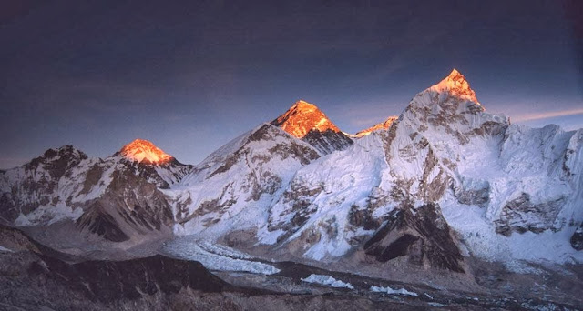
It starts with a good slope to leave the town. With the clear sky and the sun giving it all the views were great. The most spectacular peak that can be seen from the village is the Langtang at 6571 mt. Going up we go through an abandoned airport and go up through a field of yaks. At the end of the hill it turns until Ama Dablam first appears, an impressive peak of 6800 meters, and then we realize that the peak that you see in the background is Everest.
Not only Everest, next to it is Lhotse, at 8,000 mt. The route continues to a hotel that I have read has the Guinness record of being the highest hotel in the world. They have a terrace with spectacular views. We sit in a viewpoint trying to see Everest since the bad weather prevented us. Then we had a Lemon tea on the terrace of the Everest Hotel.
After the hotel the road goes down to the village of Khumjung. In this part we walk on snow and visit the stupa in honor of Edmund Hillary, very photogenic with the Ama Dablam in the background. From the stupa we arrive to the village. The town is authentic, that practically subsists thanks to the donations of Edmund Hillary (first to climb the Everest) who built a school there and even a hospital.
In the village we see people washing clothes in the river, picking potatoes, carving, directing the yaks. Children are seen going to school. We see stupas and stones carved with the mythical mantra of om mani padme hum. Going down to Namche the clouds begin to cover everything. Arriving in Namche the afternoon was spent together with a couple of English and although at times disconnected I am talking more than I imagined.
We went to eat at our lodge, and then we went to a nearby cafe to have a pasta and a coffee. It was very comfortable, and above with free wifi. In the evening we met to finalize the stages of the following days. After dinner, we play cards and chat for a while.
Day 4 - Namche - Phortse
At 6:30 we have breakfast. The night has been very bad so I was awake before the alarm clock. After breakfast I fix the backpack and I remove some weight to leave them at the hotel and pick them up on the way back. The route today starts from Namche on an important slope to enter a path that runs over the valley, with Ama Dablam, Everest and Lhotse in the background.
The most tourist route is the one that goes from Namche to Tengboche. I, on the recommendation of Tripadvisor, will do from Namche to Phortse. The beginning of the route is very cool with a lot of vultures flying very close, the bad is that it seems a pilgrimage, it is the first time I meet so many people, fortunately this is only the first 4 km and then when you take the detour to Phortse the thing changes.
The road to Phortse begins with a climb from a beautiful forest. A curious thing, for those who have played the Mario Bros and remember the sound made by the ghost Boo when he laughed, because there is a bird that makes exactly the same sound in that forest!
As we gain altitude the landscape becomes more arid but the views are great. Today we climb 1000 meters of altitude and the height is very noticeable in the fatigue. All along the way we came across a caravan of yaks and a couple that got off because one of them felt bad. To get to Phortse we go up to 4000 meters where there is a village, Mong. There we met a couple of Russians who were in the same hotel in Namche and we eat there with them.
For a good acclimatization, it is good to spend a lot of time at the maximum height of the day. After an hour and a half we continue to Phortse, the road goes down to 3,600 driving into a forest very lord of the rings and then up to Phortse which is at 3800 along a path full of snow. This last climb has killed me but the stage is done. 12 km with 1000 altitude difference, the altitude and the backpack have made me go slow and the slopes have become durillas.
Phortse is a very basic town where people are working, building their houses, carrying things from one house to another. We arrived at a lodge that they opened this year and for one euro they give us a single room and dinner for all. At the entrance there is a field of potatoes where the women are working and two small children playing in the sand happier than nothing, they do not have fixed allergies.
The youngest has been caught by his mother and in a basin of water she started to bathe him outside, at 2 degrees! At dinner we are with an American. At nine I'm in the sleeping bag, in the room at -2 degrees. I'm wearing thermal tights, a thermal T-shirt, the polar one, the coat, the balaclava and the gloves.
Day 5: Phortse - Pheriche
Today I slept perfect. Sleeping with the coat is the invention. At 6:30 am I was having breakfast, the sky was clear and with the morning scratch, the good thing about it is that as soon as the sun goes down it is fine and almost all day I go with the breathable T-shirt and the windbreaker.
In Phortse, and henceforth, there is no running water, so the water that is used is from the rain and the river, I have filled the water tank and with the water purification tablets I can drink without fear. Today's route has been 13 km and 900 of unevenness, is all the time by the slope of the valley at 4000 meters, the views are very cool and opposite the classic route with the monastery of Tengboche.
The impressive thing is that of the vultures. The route goes down to a village, Pangboche, where we have a tea. The village has a Buddhist monastery that can be visited along with a very close view of Ama Dablam. At the exit of the town, about two kilometers away there is an impressive point, a series of stupas and flags, all surrounded by impressive peaks, following the clockwise direction: the Thamserku of 6608, the Langtang of 6571, the Ombigachang of 6340, the Ama Dablam of 6812, the Lhotse of 8516, the Nuptse of 7861, the Everest of 8850, the Tawache of 6542 and another peak of 5000 and a few meters that the name does not appear in the GPS.
The road to Periche is entirely a high mountain snowy landscape, we go to the river and it goes up stepping on mud, snow and ice, the vegetation is just bushes and we cross more yaks than people. As always the clouds have been covering the valley as we went and after ten minutes in Pheriche the clouds have already been thrown over.
In Periche there is the Himalayan Rescue medical center led by volunteer doctors and every afternoon they give a talk about altitude sickness. We arrived just in time for the talk and the truth is that it is very good. At the end we take the saturation of oxygen in the blood and the cardiac rate.
We are at 4200 meters so oxygen is 60%. Our saturation should be between 85 and 90 and resting heart rate less than 110. The lodge is costly. Tomorrow is a day of acclimatization in a town that is at the same height as Periche.
Day 6: Acclimatization in Dingboche
Today has been hard on the nose. As it is a day of acclimatization, we have to sleep at the same height so that in order not to spend two days in Pheriche we go to a nearby town called Dingboche. The town is the same as Periche but with a stupa, maybe it is warmer than because it captures more hours of sun and has more lodges.
It's more expensive than Pheriche. The truth is that I would have stayed in Pheriche if I came to know that the towns are practically the same. In the days of acclimatization the norm is climb high and sleep low. Next to Dingboche is a peak, the Nangkartshang of 5616 meters. At the peak one cannot climb only walking but this peak has two sides and the first can be done walking with sticks.
It has taken almost 5 hours to go up and down, although I have spent a bit of time with photos and videos. The route itself has some impressive panoramas, it goes up with the Ama Dablam behind and the Tabuche on the left and on the right the Chukhung valley with the Island Peak in the background. You go through a very photogenic stupa and the path goes up between yaks and with the vultures within a hand's reach.
From the top the views were unsurpassed. All the mountains with the clouds beginning to cover them and all full of prayer flags. On the other side of the Chhukung valley are all the peaks that are seen during the climb along with the Makalu (8481 meters) in the background. After the photos and videos and a good time of contemplation, we turn carefully using the canes. The descent becomes more entertaining to be able to alternate with some run.
We spent the afternoon reading and talking in the common room. We met a girl from New Zealand and the rest are almost all Americans. The internet did not work. They say that sleeping at height is uncomfortable but for now I am sleeping like a man although before sleeping it seems like I sigh more.
Day 7: Dingboche - Lobuche
I woke up at 6 and at 6:30, as they did not want me to do breakfast in my lodge, I went to another nearby for breakfast and on top with wifi. The route ascends to Lobuche where I will sleep at 4900 meters. First it goes through a wasteland with Tabuche (6495) and Cholatse (6335) on the left.
In this part we are practically alone and we crossed paths with a couple of Japanese, one of them was without sunglasses and in short sleeve shirt with burned arms and a backpacker like me, towards 0 degrees, all snowy and with sun. It seemed that I was doing penance because three kilometers later it was the same.
The route reaches a village, Dughla and from there it rises to 4800. In that town Max and I meet a boy who turns out to be Catalan, Marçal, travels alone and joins us the next two days. It takes six months of travel in Asia and the bad thing is that for not doing the ugly to Max, when we all agree on the breaks we try to speak in English, but when we do not appreciate speaking in Spanish.
The climb, after Dughla, is annoyed but better than yesterday, it shows that maybe it is better acclimatized or that the climb is not so pronounced, yet you have to go resting every little bit. At the end of the climb, the landscape becomes snowy and you come across the cemetery of mountaineers, where there are tributes to many of the dead on Everest. At that moment it begins to snow, the atmosphere is authentic.
From the cemetery to Lobuche everything is snow, it has not been necessary to put on the mini crampons because it is practically flat but the truth is that it gives a bit of shit to go through a landscape so surrounded by clouds, mountains and yaks knowing that you are at almost 5000 meters and on top of snowing, after all this is the bug of the matter. Thank goodness to change the boots for some with goretex in good condition because they are 4 kilometers walking through snow.
When we arrived at the lodge we went in and there was a Japanese man who looked like he was having a bad time! The helicopter begins to be heard from a distance so I fly out and the helicopter appears on a recon turn and lands 30 meters from the lodge in the middle of the snow while carrying the Japanese and in five minutes it returns to take off in a blizzard.
The hostel is fine but at 4900 meters it is all frozen. Here there is a telephone with international calls to be able to give signs of life and it is not very expensive. Tomorrow I will do Everest Base Camp. One option was not to do the base camp and jump to the next valley through the Chola Pass, which is 5300 meters, but a week ago there was a snowstorm and it is closed until mid-April.
Jumping into the other valley without going through the pass would take me two days and I prefer to change the landscape and be able to see the area of the Annapurna. It is a change of plans that was within what was planned, in return I will see the Base Camp and I will return for Tengboche. In the hostel they have an oximeter.
Day 8: Lobuche - EBC - Gorakshep
The night, although it has been cold I have slept quite well. I've already taken the trick to breakfasts. At this point everything is expensive and for nothing you already get 5 euros. Typical is the Tibetan bread and with sugar and a little coffee on top is tremendous, even if the Sherpa looked strange to me.
Today the route has been 13 km with 800 gradients. Until 12 it's all ice and snow and the mini crampons have been very useful. The route has no difficulty whatsoever except for the height, I did not imagine that it would get so tired, the mere fact of hitting a trot in plain fatigue.
The first part begins Gorakshep direction, is like going slowly into the middle of a pot surrounded by mountains, next to us always accompanies the Nuptse and across the border with Tibet where the Pumo Ri is the prettiest with its pyramidal form. The thermometer marks -7 but it makes an important wind and with everything snowed it seems Antarctica.
Gorakshep is the last town before Everest, formerly the Everest Base Camp. Here we will spend the night at 5200 meters so we take a room and unload the backpacks to go to the base camp without weight. On the internet I read that the base camp is not worth it. Well, after reaching it, I can already give my opinion and it's not worth it, but it's essential.
If what you are looking for is a base camp where you look up and see Everest, you will not see it because you cannot see it from the base camp even when you are there. The road to the Base Camp is totally different from what I've seen and a very beastly landscape. It goes walking all the time next to the glacial tongue of the Khumbu.
The environment is chilling and icy while one approaches the Khumbu glacier under which the camp is located. The Nuptse almost pass by her skirt and we can see glacial lagoons and ice cliffs. It is like the glaciers of Iceland but disordered, since the landslides from the mountains fill the rock glacier. The base camp is on top of the same glacier, just in front of the Khumbu waterfall, which climbs those that go to Everest.
Upon reaching the camp we find some stones with the name of Everest Base Camp and thousands of prayer flags, photo and video of rigor and we visited the first expedition that is installed. They are still shops with all the comforts of the world. The environment is great with a frozen lagoon, a ravine, the tongue and the glacier with sauteed little shops while the sherpa are heard singing.
There is a constant flow of yaks that are supplying the expeditions and in this stretch we can see that they have a hard time because they walk on the same glacier and more than one slip stick. Taking the road back even though the drop is negative is a rise and fall that has broken me. Above the yak caravans run like Jumanji because, as they go empty and it's downhill the Sherpa pulls them.
When arriving at the hotel the only high is the food because it continues to be -7 degrees. My room has a window, because a room of it is under the ice. The batteries of the mobile and the ebook mark that they are unloaded but as soon as they warm up with the body they recover the load.

Kalyan Panja
Kalyan Panja is a photographer and a travel writer sharing stories and experiences through photographs and words


